The week ahead
Outlook summary
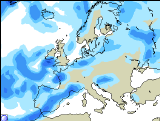 Unsettled, wet, cold and windy with some snow in the north is the sad news on next week's weather.
High pressure will keep the southern areas mainly dry and cold over the weekend, while low pressure over northern areas is causing some milder, but much wetter conditions.
The south will slowly cloud over and the beginning of next week will see low pressure and fronts moving southeast, rain for all parts and breezy winds for northwestern areas. Monday's and Tuesday's dull weather will also allow some shy sunny spells between the fronts. Temperatures average to mild.
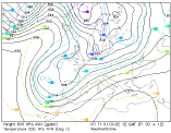 Mid-week will see very developing low pressure systems rushing towards the British Isles, driven by a strong jet stream. Widespread heavy rain and breezy westerly to southwesterly winds are likely to batter Ireland and the southern UK, where the temperatures will be average to mild. There is a significant risk for gales. Those systems will also scoop cold and wet arctic air into the northern UK, bringing nighttime frost, wintry showers and hill snow.
For further information check our regional 10-day outlook.
Forecast valid for Sunday, March 3rd to Saturday, March 9th.