Weather Facts
Wall Cloud
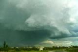 A Wall Cloud is a small-scale isolated and persistent lowering from the rain-free base of a thunderstorm, or supercell thunderstorm. Normally it is found on the inflow side of the storm, which is to south or south-west in the Northern Hemisphere. Wall clouds range between 1 and 8km (1 to 4 miles) in size are often associated with the area of strongest updraft (upward motion) in the storm.
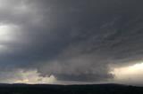 As the thunderstorm intensifies, the updraft draws in low-level air from the precipitation area. This rain-cooled air is of high relative humidity, and this moist air quickly condenses to form a wall cloud. However, some even exhibit cyclonic rotation, and these often develop into tornadoes, which is also known as lowering of the cloud.