New Weather Satellite
NOAA-17 sends first picture
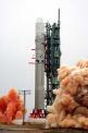 The National Oceanic and Atmospheric Administration (NOAA). launched its newest environmental satellite of the NOAA-series on Monday from Vandenberg Air Force Base in California, NASA said. The satellite NOAA-17, named NOAA-M until reaching Earth orbit, was launched on the back of a Titan II rocket. The information it collects will be shared by NASA and the NOAA.
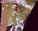 NASA will turn operational control of the NOAA-17 spacecraft over to NOAA 21 days after launch. NASA's comprehensive on-orbit verification period is expected to last until approximately 45 days after launch. In the meanwhile the first image from space sent by NOAA-17 was beamed to NOAA today, showing cloud patterns over the Great Lakes area.
The NOAA-M satellite will improve weather forecasting and monitor environmental events around the world ... and will enable continuity of data for monitoring events such as El Nino, droughts, volcanic ash, fires and floods
said Conrad Lautenbacher, under-secretary of commerce for oceans and atmosphere, and director of the NOAA. In addition to imaging equipment and classic ultraviolet and infra-red, the satellite will also be equipped with microwave instruments allowing it to see under cloud cover. Like other NOAA satellites, NOAA-17 will collect meteorological data and transmit the information to users around the world to enhance weather forecasting. In the United States, the data will be used primarily by NOAA's National Weather Service for its long-range weather and climate forecasts.
The latest of the polar-orbiting satellites, being NOAA-16 was launched on Sptember 21, 2000.
Related features:
The NOAA-series
Polar Orbiting Satellites
Weather Online's NOAA imagery