After the storm
Showers and cool
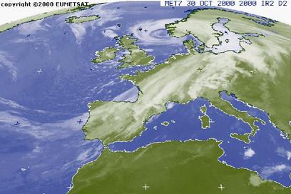 The massive low that was responsible for the worst storms in Britain in over a decade is slowly filling up off the coast of Norway.
Cooler air and showers are coming in with westerly winds on the backside of it's huge cold front, reaching from the southern
Mediterranean to South Sweden. Although this one is getting weaker, low pressure systems of this size and around this time
of the year are pretty stable features. Therefore, cool air and showers from the west with breezy winds will dominate our weather during the
next couple of days. The best we can hope for are some sunny moments between two cold showers. On Thursday, showers will be less frequent
and sun will last a bit longer in the East, but the air will still be rather cool. There might even be some frost on early Thursday morning in Eastern
Scotland and Northern England.
The massive low that was responsible for the worst storms in Britain in over a decade is slowly filling up off the coast of Norway.
Cooler air and showers are coming in with westerly winds on the backside of it's huge cold front, reaching from the southern
Mediterranean to South Sweden. Although this one is getting weaker, low pressure systems of this size and around this time
of the year are pretty stable features. Therefore, cool air and showers from the west with breezy winds will dominate our weather during the
next couple of days. The best we can hope for are some sunny moments between two cold showers. On Thursday, showers will be less frequent
and sun will last a bit longer in the East, but the air will still be rather cool. There might even be some frost on early Thursday morning in Eastern
Scotland and Northern England.
For the next two days winds will mainly come from westerly directions. Winds might become a little stronger again around Wednesday noon,
especially in the South and West. However, for the moment, the big storms are over. Flooding could still be a topic in the western part of the
country, but the situation for most rivers should ease by Thursday.
Highest temperatures will vary between 5°C and 6°C and 9°C to 10°C. Minimum temperatures will be around 4°C to 6°C, but cooler where the sky is clearing
up during night-time.