Featured Weather Event.
A Troughing Wind-up!
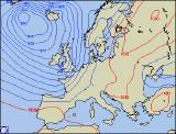 During the early hours of Thursday morning (8th January 2004), a vigorous trough swept into south-western parts of the UK. Developing and winding up rapidly, this trough quickly formed a small but intense area of low pressure, with associated weather fronts, which raced across much of the UK during Thursday morning and afternoon. The first image shown here displays the pressure pattern during the morning, with the new low centre already developing over South Wales.
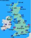 The first affects of this rapidly deepening system were high westerly winds speeds. Gusts of over 50mph were reported around many coastal regions across southern parts, from the Pembrokeshire Coast, across the East Anglia. The highest gust during the day was near Southampton, at just shy of 75mph, and these winds were reported to have caused minor damage to trees, as well as disruption to road and rail links. The second chart displayed here shows where some of the strongest gusts were recorded, although for archive reasons Southampton's strongest gusts are not listed.
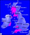 As well as high wind speeds, a good deal of heavy rain was produced by this system. Between 25 and 40mm (1-1.5 inches) of rain fell across south-west England and south Wales, and this was enough to give minor flooding and the closure of several roads. The highest rainfall was across Tulloch Bridge in the Highlands however, where over 50mm (2 inches) fell during the afternoon. Numerous small landslides were reported across Scotland, as the soils became saturated with rain water. The third image here shows where the highest rainfall totals were reported (shown in bright pink). Less unsettled, showery weather followed to many parts during Thursday afternoon and evening, although with thunderstorms reported along the south coast. The outlook is for further wind and rain, with the possibility of severe gales early next week.