Storm Watch: 26/10/04 - 27/10/04
Gales and rain set to batter the west.
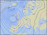 We're currently keeping a close eye on a very intense depression which is forecast to develop to the south-west of the UK later on Tuesday and into Wednesday. The exact track of the low pressure centre, together with the intensity of associated winds, is varying between model outputs, but one thing is for certain - it will be wet and extremely windy!
 Areas most at risk from the strong winds will be the south-west of England, southern and western parts of Wales, and large parts of the Irish Republic. Winds are expected to reach sustained values of up to 30mph inland, with gusts as high as 60mph. Around the coasts, these gusts may reach anything from 70-85mph, perhaps even higher. Winds of this strength are capable of causing structural damage to buildings, and with trees still in leaf, both severe damage and even uprooting is possible.
 The low's centre, depending on the forecast model, looks set to become stationary for a time off south-west England, before transferring slowly northwards towards Ireland on Wed. In a classic "bomb" development, the central pressure of the low is forecast to deepen by up to 40mb in only 24hrs, with the central pressure becoming as low as 958mb, making this a significant Autumn storm. We'll update this page when the level of detail on this depression increases on Tuesday evening, but in the meantime you can view our current Atlantic satellite observations as the storm begins to develop.