Storm Watch: 27/10/04 - 28/10/04
The storm is upon us!
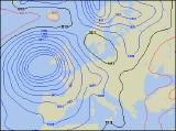 As predicted, an explosive area of low pressure has developed throughout Tuesday off the west coast of Spain, and is now heading towards the south-west of the UK. Already, windspeeds are being recorded in excess of 50mph around the developing system, and with vast plumes of rain-bearing cloud, the intensifying depression is making roads towards us.
Little detail has changed with the predicted track, and during the early hours of Wednesday morning, the first effects of the storm will be felt across Devon and Cornwall. With central pressure expected to rocket to below 955mb, this will be by far the most intense storm of 2004 so far. During the day on Wednesday, sustained wind-speeds are expected to reach 45-50mph across south-west England and southern parts of Ireland. Through the afternoon and into the evening, these wind speeds may increase around the coasts of south-west England , Wales and Ireland, to as high as 60mph, with gusts of up to 85mph a distinct possibility.
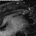 Once again, with trees still in leaf, significant damage may occur with many tree-limbs brought down, and even uprooting of trees possible. Slight structural damage is possible to buildings and structures, especially across Cornwall and southern coastal areas of Ireland. Although this Autumn storm will contain some heavy rain, the largest problem facing us is that of wind-speeds. To see the position of the low at present, please view our satellite observations page. For current wind-speeds, and the locations of the most damaging gusts, please refer to our current conditions pages. Once the storm has set in during Wednesday night, with the ongoing risk of severe gales, it's presence will be felt throughout Thursday and Friday, with some extremely torrential downpours and thunderstorms likely.