Storm Watch: 28/10/04
South-west is pounded! More to come!
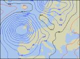 After bottoming out at a central pressure close to 950mb by early afternoon on Wednesday, the intense depression to the south-west of the UK gave a day of high winds and rain across south-western parts of the UK, and southern parts of Ireland. The intensity of the winds up until 6pm BST were every bit as strong as the forecast predictions, with Cornwall, Devon and southern and eastern counties of the Irish Republic coming off worst!
During Wednesday morning, the south to south-easterly winds increased steadily, with gusts of up to 50mph and sustained winds of around 25-30mph. During the afternoon, gusts of wind were reported of between 60 and 70mph across southern parts of Cornwall, the Isles of Scilly, and across southern and eastern coastal parts of Munster. Disruption has been numerous, with villages in south-west England losing power, many downed trees blocking roads, and disruption to air travel. Around the coast, huge seas have pounded southern coastal areas of Devon and Cornwall, with promenades closed off, and sea-front properties being battered by waves and spray. Most ferry services from the south-west of England and through the Irish Sea have been cancelled. In places, more substantial damage has been reported, with toppled walls and roofs being damage or ripped off in parts of Cornwall.
 Now a stunning swirl on current satellite images, the storm at the centre of this mayhem has now parked itself just to the south of the Irish coast, and there it will remain. During Wednesday night and through Thursday, further gale to severe gale force winds are forecast to batter coasts of Ireland, Wales and south-west England, with gusts perhaps exceeding 80mph. Together with this, heavy and thundery downpours are forecast to break out both during Thursday and Friday, so this storm has certainly not finished with southern and western parts of the UK just yet.