The Month Ahead
30 Day Outlook for July/August
 Mixed, some warmer, drier spells
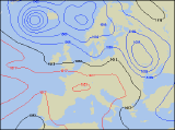
There seems to be little to indicate, at least in the short term, any let up in the mainly zonal, westerly airflow.
That said, our forecasts expect that as we approach the final week of July the unsettled, westerly flow will weaken and at long last, high pressure should start to build. The ensuing anticyclonic spell is then likely to dominate the weather pattern until the end of July, and it may even become very warm.
The beginning of August should see the anticyclonic spell ending with a thundery breakdown and a change back to a more westerly regime once more.
After another spell of rather mixed weather at the beginning of August, pressure will once again rise over the southern half of the UK and Ireland. Winds will stay in the west to southwest with much of the unsettled weather across northern parts of Ireland and Scotland. More southern areas will be favoured with drier and settled conditions.
 Updated Monday 12th July 2004. Valid Tuesday 13th July 2004 to Wednesday 11th August 2004
Issued by Weather Consultancy Services Ltd in cooperation with WeatherOnline Ltd.
Subscribe for a detailed week to week forecast of the month ahead! Inquire terms and conditions here!
Compare with past Julies
Average Temperature
Average Frost Days
Average Days with Precipitation