Weather News
Winter blasts US North-East
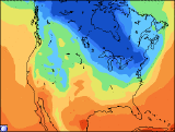
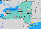 New York - A cold front hit the northeastern United States Wednesday as the region prepared itself for polar winds by Thursday, with thermometers expected to fall to minus 15°C in New York.
In the Boston area, temperatures might drop velow 20°C; and New York, New Jersey, Maine and Connecticut have issued cold weather alerts.
 The first shot of Arctic wind which arrived Tuesday evening has already produced wind chill values as low as 10 degrees below zero across the (New York) metropolitan area during the morning hours, as weak high pressure builds over the area this afternoon, winds will diminish and wind chill values will rise to above zero. However, a new round of reinforcing Arctic air is to pour into the region Thursday night creating very high wind chill levels again.
 The effect is due to air temperatures falling to between zero and five degrees combined with northwesterly winds of 32-40 kilometers (20-25 miles) an hour. Exposed skin at such readings can become frostbitten in 30 minutes. In some part of the US North-East, snow could fall to a depth of 10 cm (4 inches). In southeast Canada Wednesday the wind chill factor forced temperatures down to minus 40°C.
Copyright 2004 - AFP & WeatherOnline