Green or white
Christmas 2000
 During the recent days the models were going on and off for snow on Christmas Day. It wasn"t looking good for a while, but the latest model output shows that the chances are increasing.
Well, this is teaching us a lesson: there simply is no reliable or scientific way forecasting the weather for more than 12 days ahead yet.
After 10 to 12 days even the latest super-dooper mega-computers at the UKMO (United Kingdom Met-Office), NOAA (US) or at the European Centre for Medium-Range Weather Forecasts - ECMWF drop down to a probability of about 50 %. You might as well roll the dices then. Keeping this in mind, you might prevent yourself from getting disappointed about so-called "long range weather forecasts" over several weeks or even a month or so.
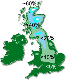
During the last 24 hours Christmas 2000 has increased its chances for snow on the early morning of December 24. For those who live near the coast, lower than - let's say - 1000 ft or in southwest England there is only a very small chance for white Christmas. However, chances for the Pennines and especially for the Southern Uplands are increasing and chances for snow in the Grampian Mountains and the Highlands are pretty good by now. But remember, only if you live on higher grounds! Only the northern Highlands might see some snow down at sea level. Unfortunately most of the thin snow cover will melt away during the day and for many regions the 'snow" won"t be more than sleet. Stay tuned - we will keep you informed.