Deep Low Pressure for June
High winds and heavy rain cause problems!
 A June Storm!
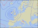
On Wednesday 23rd and Thursday 24th, a deep low pressure area raced across much of the UK. The storm was more typical of weather experienced in Autumn across the country, and with a central pressure as low as 981mb across central Wales, this was a rare depression indeed, if not record-breaking for its location. With the storm came strong to gale force winds and a huge amount of rain, throughout Wednesday and continuing into Thursday.
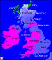 During Wednesday, the rain and strong winds affected much of England and Wales. Winds were sustained at between 30-40mph along the south coast and across South Wales, with gusts exceeding 55-65mph in places. The high winds caused disruption across the south, with houses in South Wales losing their roofing material, many trees down blocking roads and railways, and minor injuries resulting from flying debris. The strongest gust of the day was reported in the Needles (Isle Of Wight), where a confimed 81mph was reached, no wonder ferry crossings to France were suspended! The rainfall also caused major problems, including flooding across the West Country, and a landslide in Cornwall. Even in London, railway stations and roads were flooded as the deluge continued. In the South-west and South Wales, some parts received over 40mm of rain in the 24hrs up to midday on Wednesday.
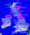 However, the rainfall made its way quickly northwards, giving much of northern England a thoroughly wet spell. In fact, parts of Lancashire and Yorkshire recorded the highest rainfall for the day on Wednesday, with nearly 45mm measured. On Thursday, the rain became slow-moving across much of Scotland, and during the 24hrs up to midday, parts of Aberdeenshire received up to 40mm. However, during the 48hrs up until midday on Thursday, the wettest places were Ballypatrick with almost 60mm of rain, and Capel Curig with 56mm of rain. The rainfall continued through the afternoon in Scotland however, so the totals for the period were only added to!