Typhoon Mawar
Japan on target
Visit www.weatheronline.co.uk - the UK's most comprehensive internet weather
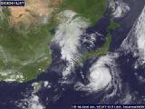 TOKYO - Powerful Typhoon Mawar could hit Japan by Thursday, weather officials said, warning of high waves and heavy rain in large areas of the country.
Mawar, located about 900 kilometers southwest of Tokyo at 6:35 am (2135 GMT Tuesday), was slowly approaching Japan's main island of Honshu, the Japan Meteorological Agency said on Wednesday.
The typhoon was packing winds of up to 144 kilometers per hour near its center and travelling northwest at a speed of 15 kilometers per hour, it said.
The agency warned of high waves and heavy rain as the typhoon approached, forecast to hit Honshu's Pacific coast between Thursday and Friday.
The last typhoon to hit Japan was Banyan, which struck the east coast in late July, delaying flights and traffic and wrecking a sailboat, although its crew was rescued.
Last year a record 10 typhoons hit mainland Japan. The last of them, Tokage, was the deadliest typhoon in a quarter-century, killing 90 people.