Feeling depressed?
Two deep depressions
By Philip Eden
Spring 2004 will be remembered among weather enthusiasts for the two very deep depressions which crossed the British Isles, one in April and one in May, bringing long spells of disturbed weather with widespread heavy rain and strong winds. Both were well predicted by most of the Numerical Weather Prediction (NWP) models.
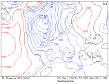 The first of these lows developed under a WNW-ly jet-stream near the southern tip of Greenland on 16th April and tracked south-eastwards to reach Scotland on the 18th. The same day a secondary disturbance formed over southern England from where it travelled northwards across eastern England, thence northwestwards across Scotland the following day. The lowest observed pressure was 971 mbar at Aberdeen at 0700 gmt on the 19th.
A preliminary search through the records indicated that this may have been the deepest April depression over the UK since 1994 when a low of 961 mbar crossed northern England. A similar pressure was logged on 11th April 1989. The all-time record for the month is 953 mbar at Stornoway on 1st April 1948.
The second low also developed off southern Greenland late on 2nd May, eventually becoming slow-moving over the UK between the 4th and the 7th. Again the lowest pressure was 971 mbar at Tiree on the morning of the 4th. This may have been the deepest May depression for over 60 years: the record was set on 8th May 1943 when the sea-level pressure fell to 969 mbar at Sealand, near Chester.
(c) Philip Eden