October Lookback
Cool and rainy
By Philip Eden
The severe gale which hit England and Wales on Sunday 26th was caused by the last in a long sequence of vigorous depressions - six in all - which crossed the country between October 13 and 27. The storm track at this time of the year is normally located between Shetland and Iceland so last month's experience amounted to a southward displacement of over 800km; this represents a considerable distortion of the usual pressure pattern over such a long period. Over the Atlantic Ocean the displacement was an exceptional 1500km.
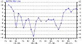 There should be little surprise, then, that October turned out to be an abnormal month over the UK. Mean monthly temperature was some 0.3 degC below the average for the standard reference period 1971-2000; this is not a large deficit, but it was nevertheless the coldest October since 1993. It is easy to forget how warm the first week of the month was, with 20C widely attained and 23C at Prestatyn, Flintshire, on the 2nd. The third week was extremely cold with widespread night frosts, the mercury falling to -7.5C at Tulloch Bridge, Inverness-shire, on the morning of the 20th, while afternoon readings that day were around 7C even in southern England. Snow fell sufficiently frequently and heavily to encourage Scottish ski centres to open two months early.
 It was a very wet month especially in eastern and southern Britain, although not as wet, broadly speaking, as the flood-ridden month of October 2000. Averaged over England and Wales the month's rainfall amounted to 135mm which is 67% above the long-term mean. The equivalent figures for Scotland were 148mm and 76% above, while the Northern Ireland total of 163mm was more than double the regional average. The Aberdeen and Dundee areas were soaked with three times the normal amount; unsurprisingly it was the wettest October here since local records began over 100 years ago. By contrast, much of western Scotland (together with parts of Sussex and Kent) had less rain than usual and on the Isle of Skye the total was less than half the long-term average.
There was a general shortage of sunshine especially in northeast England and the east Midlands where Nottingham reported a shortfall of 35%. At the other extreme Lerwick in Shetland logged an excess of 58%, the highest in October since 1939. - (c) Philip Eden
Philip Eden's UK Weather Diary and reviews: