Beware the Weekend
Forecast Discussion
Visit www.weatheronline.co.uk - the UK's most comprehensive internet weather - to get the latest weather news or talk to our forecast telephone service (09061 991 189 �1.50p/min)
Issued: 1600 GMT Monday 24th January 2005
Duty Forecaster: Simon Keeling
Here at the Weatheronline Weather Centre, we were pretty pleased with our snow forecast for last weekend. We first highlighted the possibility of colder weather 8 days before the event, and although forecasting of the detail could have been better, overall we reckon we deserved 8 out of 10 for that one!
 However, you're only as good as your last forecast and so our attention has turned to the weather over the next week or so.
As I type snow showers are continuing to affect eastern parts of England. Warmer air is now toppling in at upper levels and so I think those showers, although continuing tonight, may well turn to sleet. However, this won't prevent the roads becoming very icy so take care if you are driving.
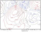
High pressure is building to the west of Ireland and this will have the effect of blocking weather systems moving in from the west and forcing air to travel around the top of it. This then sinks southwards, having picked up lots of moisture and is likely to turn our weather cloudier and damper. However, Ireland may well escape having the best of any sunshine.
 The problem for us forecasters comes at the end of the week. The low pressure area you can see over Italy is feeding much colder air off the Euro-Asian land mass, and should the door be opened, this bitterly cold air could drive it's way through the UK and Ireland.
Of course, it's fine stating this as a possibility, the real skill comes in deciding whether or not it is likely to happen. Our 30 day forecast did hint at the possibility of some freezing easterly winds moving in, and this is usually a sign to keep an eye out for such a possibility.
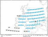
The midnight run of the GFS model (the one you see here) also highlighted this as a risk next weekend, although I think it a little overdone. What it did show though was the weather that could be associated with it, should the cold air manage to break through. The chart to the right showers the blue snow symbols over many areas, with eastern and southeastern parts of England mostly affected.
So, what are my thoughts just now? Well I think the possibility is certainly there of a cold snap for the weekend. It could well be the coldest snap of the winter so far, with bitter air and snow moving in.
Remember though, the weather can change, so I'll be posting an update tomorrow and we'll see how things transpire then.
For now, keep the sun shining!
Simon