Winter draws on!
Snow and ice!
Visit www.weatheronline.co.uk - the UK's most comprehensive internet weather - to get the latest weather news or talk to our forecast telephone service (09061 991 189 È1.50p/min)
Issued: 1500 GMT Wednesday 2nd March 2005
Forecaster: Simon Keeling
 Winter draws on! Snow and ice!
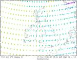
More wintry weather to come through this evening and overnight. Kent and Sussex seem particularly prone to snowfall and there is a risk of as much as 3 to 10cm of snow falling here. Most of the snow over high ground, but a risk at lower levels too. The snow probably won't clear until early Thursday afternoon.
Ice is going to be a widespread problem throughout the country during tonight. Temperatures as low as -5C will lead to dangerous driving conditions on untreated roads and so you should allow extra time for your journeys.
 Weatheronline forecasters are also monitoring another band of snow moving into northwest England very early on Thursday morning, perhaps bringing a couple of centimetres of snow here during the morning rush hour. This fading through the later morning.
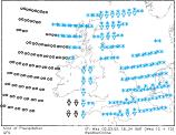
There are then indications that warmer air will move through northern parts of the country for a short time, bringing rain, some of it heavy in Scotland, Northern Ireland and northern England late on Thursday and into Friday. However, as the fronts responsible for the rain clear southwards, much colder weather will follow from the north.
The colder air is going to turn the rain to snow across northern and eastern Scotland on Friday morning, this then spreading southwards through most of England and Wales on Friday afternoon. There is a risk of some rather persistent snow across East Anglia, the Midlands and southeast England late on Friday.
As always, Weatheronline will keep you up-to-date with the latest forecast, and our meteorologists will ensure you have the best information at your fingertips.
Simon