Weekend Weather
Cold in Doubt
Visit www.weatheronline.co.uk - the UK's most comprehensive internet weather - to get the latest weather news or talk to our forecast telephone service (09061 991 189 �1.50p/min)
Issued: 0800 GMT Thursday 3rd February 2005
Duty Forecaster: Simon Keeling
After being fairly confident in predicting a cold snap, beginning this weekend, forecasters here at the Weatheronline Weather Centre are having a rethink today.
 The reason? Well, the cold weather is all dependant on how the high pressure areas builds over eastern Europe. For sometime, we've been expecting the high to build across Scandinavia, this would have led to chill easterly winds blowing acrss the British isles and Ireland, perhaps with low pressure over the central parts of Europe. This is a definite recipe for winter and we thought snow might be likely, mainly in the east.
However, the latest computer models, issued over the past few hours are now allowing the high to build further southwards, this because milder W-SW winds will blow across northern Scandinavia.
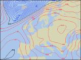
The chart to the left (for midday on Sunday) shows high pressure both west and east of the British Isles with the source of the air now critical.
The maximum temperature chart to the left shows cooler conditions, but even then, temperatures may still reach 4 or 5C across large parts of the region.
By next week the high may well have moved into central Europe with the milder winds returning.
Taking all this into account, we are therefore downgrading our warning of a wintry snap�at least for now! The chance of a cold snap into next is considered low, although this could change. Therefore I'll be keeping you up to date over the next few days, should any chance occur.
For now, keep the sun shining.
Simon