Weekend early outlook
A game of two halves
Visit www.weatheronline.co.uk - the UK's most comprehensive internet weather - talk live to our forecasters for the latest forecast and weather news. Call 09061 991 189 (Ł1.50p/min)
Issued: 0800hrs Wednesday 5th May 2005
Duty forecaster: Simon Keeling
 Fine for some. cool
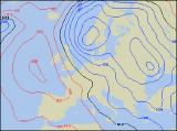
It’s another tricky weekend ahead for us weather forecasters. I’m seeing the computer models building high pressure in from the west during Saturday, although before this arrives a cold northwest wind will be affecting most areas.
The tricky bit is deciding what the weather will be like ahead of the high pressure, and whether it will assert it’s authority quickly.
Now, at the moment I think that Saturday probably sees a fair amount of showers across northern and eastern Scotland as well as northeast England and East Anglia. Southern counties of England, Wales and the east of Scotland having some early cloud and patchy light rain, but this clearing.
During Saturday it will become brighter from the west, as the high builds in and so the day is likely to end up dry and sunny over Ireland, Wales and the west of England, perhaps also in western Scotland later.
On Sunday the high strengthens itself to the west. There could be a morning frost for Ireland, Wales, western and central parts of England. A fine day then in these areas with plenty of sunshine. Still some showers over eastern Scotland, northeast England and East Anglia, a few of them heavy early on. Late in the day it should become dry. Cool in the east with the winds direct from the Arctic.
Overall, I’ll give the weekend 7 out of 10 in the west, nearer 5 out of 10 in the east.
We’ll see how my marks measure up!
Simon