Wintry Windy Weekend
Snow and Gales
Visit www.weatheronline.co.uk - the UK's most comprehensive internet weather - to get the latest weather news or talk to our forecast telephone service (09061 991 189 �1.50p/min)
Issued: 0900 GMT Friday 11th February 2005
Duty Forecaster: Simon Keeling
Forecasters at the Weatheronline Weather Centre are currently advising that there is a significant risk of a brief period of wintry weather affecting much of Scotland, northern and central parts of England through the course of Saturday evening and night.
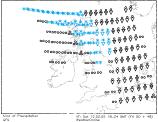 During the evening, snow will be affecting much of northern and central Scotland, bringing blizzards in many areas, as winds increase to be gusting to 70mph.
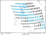
As the evening progresses the snow will be moving southwards and is mainly going to be affecting northern and western Scotland, as well as northern (particularly northwest England) in the period between midnight and 6am on Sunday morning. With the strong to gale force winds in many areas there is a risk of blizzards with accumulations of snow, making driving conditions very tricky.
Through Sunday morning most of the snow will be clearing to the south and east, with brighter weather following. It will be remaining windy and cold throughout Sunday.
 So, whatever you are doing this weekend, wrap up warm. Take great care if you are planning any outdoor activity, particularly in the north, and remember to check back with Weatheronline for the very latest weather information. You can check where it is snowing by clicking here