Colder by Friday
Chance of snow on the hills
Visit www.weatheronline.co.uk - the UK's most comprehensive internet weather - talk live to our forecasters for the latest forecast and weather news. Call 09061 991 189 (Ł1.50p/min)
Issued: 0930hrs Tuesday 12th April 2005
Duty forecaster: Simon Keeling
 There’s a chance of snow on ‘dem ‘dare hills!
A chilly one last night. Bingley in Yorkshire recorded a low air temperature of -5C. Redhill in Surrey got lows near -2C. whilst Shoeburyness, Soothampton and Winchester all recorded an air frost.
It should not be as cold a night tonight across the south, although a slight frost is likely through more northern parts of the country, with northeast England and southern Scotland most favoured.
It is later in the week that we see the risk of overnight frosts increasing. By Wednesday low pressure dips into Ireland and western Scotland bringing heavy showers here through Wednesday. The low pressure moves eastwards overnight into Thursday and as it does so it will be dragging in colder air behind it.
By Thursday the colder air will have spilt south through most of Scotland and western Ireland, these showers turning increasingly wintry over the hills. The low then shifts into the North Sea through Friday with chillier conditions probably reaching all parts of the country.
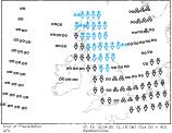
Wintry showers across the hills of Scotland, Ireland and northern England as well as northern Wales, a few of them heavy. These should fade from western areas later.
Check with Weatheronline regularly for further updates.
Whatever the weather keep the sun shining!
Simon