Will there be weekend snow?
Forecast Discussion
Visit www.weatheronline.co.uk - the UK's most comprehensive internet weather - to get the latest weather news or talk to our forecast telephone service (09061 991 189 È1.50p/min)
Issued: 1500 GMT Wednesday 19th January 2005
Duty Forecaster: Simon Keeling
The Weatheronline weather centre has been buzzing over the past few days as forecasters debated the possibility of cold air returning to the UK and Ireland during this weekend. We first spotted the possibility of this happening last Friday.
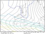 Until yesterday we were quite happy with the idea of the weekend being a cold, but dry one, as high pressure built to the west of Ireland. On Tuesday morning, things changed. The American (GFS) and British forecast models started hinting at a small low trapped in the flow, moving southeast through Ireland, Wales and the Midlands during Saturday; with cold air to the north and warm air to the south, that brought the potential of some severe weather.
However, as with all of these situations, us forecasters are aware that sometime the models can throw a bit of a wobbly and may be in error. So, we left it 24 hours. Today though, the models have repeated their predictions and so it is time to highlight the risk of some wintry weather this weekend.
So, at the moment, we need to monitor the runs of the model very carefully. There are four runs each day and you can monitor these at Weatheronline by visiting our Expert Maps
 At the moment the low is forecast to track across Northern Ireland during the early hours of Saturday morning. It could bring heavy bursts of rain, with that turning to sleet and snow on the far north. As the rain passes through Wales and England it will be heavy too, but here the colder air to the north will really be digging in.
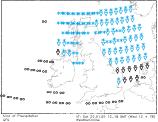
You can see from the significant weather chart that the rain is turned quite readily to snow by the model on Saturday afternoon and this seems reasonable.
The transition zone between the colder air to the north and milder air to the south is going to be sharp and so locations within a few miles of each other may see rain or snow.
It's difficult to say exactly where any snow will be as each run of the model will position the low differently in the next few days. What does seem more certain is that once the low clears, northerly winds will set in overnight bringing icy roads to many parts of the UK and Ireland.
A widespread frost is going to be occurring, although this should lead us into a fairly pleasant day on Sunday.
There's lots to look forward too and I'll have an update for you tomorrow.