Crash, bang, wallop!
Heavy thunderstorms on the way
Visit www.weatheronline.co.uk - the UK's most comprehensive internet weather - talk live to our forecasters for the latest forecast and weather news. Call 090 666 444 80 (Ł1.50p/min)
Issued: 0715hrs Sunday 19th June 2005
Duty forecaster: Simon Keeling
 Torrential downpours on Sunday
After the heat of the past few days, Sunday looks set to bring some very active weather for much of England and Wales.
We're watching colder air move in at higher levels this morning, and this mixed with the hot air at the surface will serve to make the atmosphere very unstable from around mid-morning onwards.
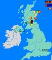
Local, torrential thunderstorms are expected to develop. They are already breaking out over southwest and central Scotland, as shown on the Weatheronline radar, updated every 15 minutes.
It will be Wales, central and northern England that take the full brunt of the storms. From around mid-morning storms will be breaking out. Although still isolated, this afternoon sees more storms with lightning, hail and some localised flooding in places. It will once again be the Midlands and parts of northern England that see the heaviest storms.
For East Anglia and southeast England the day should stay dry and hot again with temperatures up to 33C.
Phew, it's hot just typing this!
Simon