Gales, Snow, Ice ...
A Busy Day
Visit www.weatheronline.co.uk - the UK's most comprehensive internet weather - to get the latest weather news or talk to our forecast telephone service (09061 991 189 Ł1.50p/min)
Issued: 1300 GMT Thursday 20th January 2005
Duty Forecaster: Simon Keeling
Weather forecasting is a wonderful job - no two days are ever the same. We've got wind gusts to 73mph in Lossiemouth and 60mph in Birmingham this afternoon, and these speeds probably won't decrease until this evening. If you are travelling, watch out as it might make driving conditions difficult, and we've reports of trees falling across railway lines.
 However, the main forecasting concern just now is the risk of snow during this weekend. For some days we've been tracking the shallow low to the west of Ireland on Friday, and following it as it tracks southeastwards across Ireland and into Wales and southwest England during the course of Friday night.
This feature will certainly be moving quickly, but it denotes the boundary between bitterly cold Arctic air to the north, and much milder air from the Atlantic to the south. Where the two meet, we're forecasting heavy rain, but of course as the rain mixes with the colder air it is likely to turn to snow. The problem is, where will most of the snow fall?
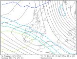
One of the ways meteorologists estimate where snow will be is by looking at the temperature of the atmosphere a few thousand feet above the ground. The best guide is the 5000ft level (known as the 850mb surface). As a rule of thumb, if the temperature is -5C or below, then snow is likely should any precipitation fall in this area. The map to the right shows the 850mb temperatures at midnight on Saturday and you can see the sharp transition zone of southern Ireland and southwest England.
 An added problem is that our forecast models aren't too good at predicting features at such a high resolution and so it is here that the skill of the forecaster comes into play. Here at the Weatheronline weather centre we've been debating all morning about where the snow will be, and what weather conditions are most likely.
So, here is my latest forecast. Just now my opinion is that the model has underestimated the extent of rainfall. Ireland is likely to be cloud and wet through tomorrow afternoon, although here any rain is likely to stay as rain, or sleet.
As the rain band moves into Wales in the afternoon it will turn increasingly to snow over the mountains, especially of northern Wales, with a chance of heavy rain in the south. Southwest England is also going to be wet.
The Midlands then turn wet on Friday evening, and it is here that we may start to see the main problems. Areas southwest of Birmingham, to about Bristol and Southampton are at risk of the precipitation starting as rain and then turning to snow. I don't think there will be too much lying snow around, although I have seen these situation before and they can turn nasty very quickly. Any area that does suffer from substantial snowfall is likely to be very confined.
 And don't think that because you live away from this area that you have escaped. There are likely to be snow showers along eastern coasts of England and Scotland, brought about by the freezing Arctic wind. Not only this, but during the night a widespread frost will develop. This will bring icy roads.
England, Wales and Ireland will find the fallen rain, sleet and snow freezing too which could make travelling conditions treacherous on Saturday morning.
So, all in all, a very busy few days head weatherwise. Do take care and listen to the latest forecast, winter has returned!
Whatever happens though, keep the sun shining!
Simon