A Cold Weekend N & E
Snow for Some
Visit www.weatheronline.co.uk - the UK's most comprehensive internet weather - to get the latest weather news or talk to our forecast telephone service (09061 991 189 �1.50p/min)
Issued: 0900 GMT Friday 21th January 2005
Duty Forecaster: Simon Keeling
It's always difficult to know when to raise an alert as to the risk of snow. We at Weatheronline have been forecasting a cold snap for this weekend for the past eight days with a chance of snow highlighted earlier this week.
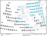
 It now seems that that risk of snow is justified as the latest forecast charts show a shallow area of low pressure moving southeast through Ireland this afternoon and then clearing southern coasts of England on Saturday morning. The sequence of pressure charts shows this very well.
The chart to the right is for midnight on Saturday and by then I think there will be periods of fairly heavy rain across Ireland, Wales and southwest England as well as parts of the Midlands. The problem comes as the low crosses Wales and southern England during the early hours, as cold air will be then be tracking down the North Sea and meeting the rain across parts of the southwest Midlands and eastern Wales.
 Snow
Snow
Weatheronline are now issuing snow risks for this evening and overnight, until the early hours of Saturday morning for Powys, Gwent, Herefordshire, south Staffordshire, south Shropshire, Gloucestershire, Warwickshire and Somerset with a risk of the rain turning to snow through Wiltshire, Oxfordshire, Berkshire and Hampshire later. This list is not exhaustive, so if you are planning on travelling this evening or overnight, do take care and check official warnings.
Snow showers are also likely to affect eastern and northern Scotland as well as eastern England.
Flooding
In those areas where the rain does not turn to snow, flooding is a concern. The ground is already damp and so a short period of relatively heavy rain may add to the water and cause roads to flood for a while. You should refer to the Environment Agency for the latest flood warnings.
How much snow there will be is uncertain, but some areas, especially the Midlands and mountains of Wales may see a couple of centimetres by the morning.
The rain may well linger across southern Ireland and southwest England for most of Saturday; the longer the rain stays the higher the risk of it turning to snow here. At the moment I think that this is probably only likely over the moors and mountains.
Ice
In other areas, or places where rain clears a widespread frost is expected. If there has been any precipitation during the evening or daytime then this is likely to freeze and is going to cause any untreated roads to become very slipper.
Rest of the weekend
High pressure is then expected to establish itself for the rest of the weekend. This will bring cold conditions to all parts of the UK and Ireland. Snow showers are possible across eastern England, with more [persistent and heavy snow a distinct possibility across Scotland. It may become windy on the eastern coasts of Scotland too on Sunday.
Whatever happens, keep the sun shine and have a good weekend.
Simon