Rough weather ahead
Batten down the hatches!
Visit www.weatheronline.co.uk - the UK's most comprehensive internet weather - talk live to our forecasters for the latest forecast and weather news. Call 090 666 444 80 (Ł1.50p/min)
Issued: 0730 Monday 22nd August 2005
Duty forecaster: Simon Keeling
 Get set for a blow....
At this time of year the pressure pattern in the Atlantic is such that very warm, moist air can travel from the Caribbean, along the eastern coast of the USA and into the north Atlantic. Responsibility for this lies with the Azores high. But why should that affect the British Isles?
Well, all of this warm and moist air mixes with cooler air in the northern Atlantic and the result can be some viscous depressions. You'll of heard to these depressions as former tropical storms. However, they are much modified versions of tropical storms and may simply have some of the warm air that went to make the storm trapped within it.
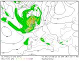
This is what is going to happen through late Tuesday and into Wednesday this week. An area of warm, moist air is going to meet with some much colder air coming from the North Pole in mid-Atlantic, around 55N. These will cause a rapidly deepening low pressure system to form. The low will move between Scotland and Iceland, bringing some very wet and windy weather for most of the UK and Ireland through Wednesday.
There could be as much as two inches of rain on western facing hills and coasts, with almost anywhere possibly getting an inch of rain.
Winds will be a feature too, especially in Ireland, Scotland and northern England. Here there will be gales, with severe gales in Scotland with gusts to 60mph, that's strong for this time of year.
The strongest winds are likely from around 6pm Tuesday evening to 9am on Wednesday morning for most of us.
Despite the forecast, whatever the weather, keep the sun shining.
Simon