More snow tonight
Midlands & East
Visit www.weatheronline.co.uk - the UK's most comprehensive internet weather - to get the latest weather news or talk to our forecast telephone service (09061 991 189 �1.50p/min)
Issued: 0900 GMT Wednesday 23rd February 2005
Forecaster: Simon Keeling
 Snow tonight in Midlands and East
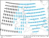
Ice and snow are widespread across the British Isles this morning. After near continuous snow showers through much of eastern England overnight we are getting reports of an inch or two of snow in many places see here. This is leading to tricky driving conditions and very icy conditions underfoot, especially on untreated roads and pavements.
 However, our attention is now being drawn to the risk of snow during the coming night (Wednesday into Thursday).
The Weatheronline Weather Centre is forecasting that snow showers will be merging together during the coming night across eastern England. These will lead to spell of more persistent snow through this evening. As the evening progresses into the night the snow will be moving westwards into the Midlands, and there is a chance of a few heavier bursts, especially across southeast England.
Widespread accumulations of between 2 and 8cm of snow are expected, with the chance of most snow probable across East Anglia and the East Midlands as well as the Home Counties. Accumulations will be more across the hills.
Ice and snow will be a problem for travellers on Thursday morning, when the snow will be into Wales and southwest England. By then it may briefly turn to sleet or rain, although as this falls onto frozen surfaces it will only exaserbate the ice problem.
So, if you are travelling in the next twenty four hours, take extra precautions.
WeatherOnline will update this forecast by 5pm today. In the meantime, keep warm!
Simon