Torrential storms on the way
Flooding risk
Visit www.weatheronline.co.uk - the UK's most comprehensive internet weather - talk live to our forecasters for the latest forecast and weather news. Call 090 666 444 80 (Ł1.50p/min)
Issued: 0830hrs Thursday 23rd June 2005
Duty forecaster: Simon Keeling
 Risk of flooding on Friday
For several days I've been warning of the risk of a return of torrential thunderstorms on Friday, and it seems that this forecast is going to be correct.
After more heat builds up through Thursday across much of England and Wales, and further hot air moves northwards from France, cooler Atlantic air is going to be trying to move in from the west.
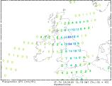
The contrast between this hot and cold air is going to be sufficient to trigger some heavy thunderstorms across England and Wales through Friday. At the moment it seems that the heaviest of the rain will be passing through southwest England and parts of Wales and northwest England through Friday morning.
After a hot start in the Midlands and southeast, thunderstorms will be forming here, merging into into longer spells of rain, with the northern Midlands and northern England at most risk of torrential downpours. There could be as much as 50mm of rain falling in a few hours in some locations.
If you are going to be out and about on Friday, do take care. be prepared for localised flooding and the onset of sudden, heavy downpours of rain and hail.
The good news is that the downpours and rain should clear into the North Sea on Friday night, with fresher weather following from the west.
Simon