Severe Frost Ahead
Wintry Watch For Sun/Mon/Tue
Visit www.weatheronline.co.uk - the UK's most comprehensive internet weather - to get the latest weather news or talk to our forecast telephone service (09061 991 189 �1.50p/min)
Issued: 1500 GMT Friday 25 February 2005
Forecaster: Simon Keeling
 Winter Weather Watch for Monday/Tuesday
Here at the Weatheronline Weather Centre we're beginning to monitor the risk of some heavy snowfall affecting parts of the country during Monday or Tuesday.
At present we are getting conflicting indications as to the severity of the snowfall, and the probability of it occurring, but we are confident that some very cold weather, and wintry conditions will affect the country early next week.
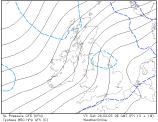
 Just now thoughts are that an area of low pressure will be passing close to Scotland on Monday. This is forecast to move southwards into the North Sea.
The low does have cold air behind it, and as it moves south the cold air will mix with rain, turning it to snow.
Exactly what happens to the low is unclear, but latest hint are that it may cross England.
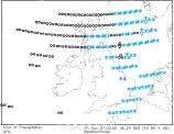
So what will this mean for our weather? Well, currently, we think that rain will affect western Scotland, slipping southwards on Monday afternoon, and onto the coasts of Wales through Monday night and Tuesday. Further inland, precipitation is expected to fall as snow, and this may be heavy over northern England and the Midlands on Monday night.
Snow into southern England on Tuesday morning and again this could be heavy, although may be rain still in west Wales and western Cornwall. A chance of the snow lingering over southern counties of England through Tuesday night.
With the winds becoming northerly behind the snow, ice will become a major problem for Tuesday night.
At present our confidence is best described as low to moderate, but we'll be firming up our thoughts over the weekend. At present though, be alert to the risk of some very cold, wintry weather early next week. br>
Simon