A fine few days, then thunderstorms
Low pressure winds the battle in the south
Visit www.weatheronline.co.uk - the UK's most comprehensive internet weather - talk live to our forecasters for the latest forecast and weather news. Call 090 666 444 80 (�1.50p/min)
Issued: 0830hrs Sunday 26th June 2005
Duty forecaster: Simon Keeling
 More thunderstorms by Wednesday
I'm carefully watching low pressure developing to the south of the British Isles this morning. It's currently through Spain, and will be moving slowly northwards into the middle part of the coming week.
There will be some very warm air associated with this low and this is going to be enough to trigger thunderstorms.
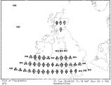
After a fine day on Monday and Tuesday for most of the UK and Ireland, cloud and rain will be spreading northwards.
By Monday evening showers will be moving into southwest England. On Tuesday the showers will become more widespread over southwest England, spreading into Wales, and then southern coasts of England. The rain and showers eventually pushing into the southern Midlands and southeast England through the evening and overnight.
This then introduces a more general breakdown in conditions through the British Isles and Ireland, with an unsettled end to the week.
Whatever the weather, keep the sun shining!
Simon