Wintry start to March
Where will the snow go?
Visit www.weatheronline.co.uk - the UK's most comprehensive internet weather - to get the latest weather news or talk to our forecast telephone service (09061 991 189 È1.50p/min)
Issued: 1000 GMT Monday 28 February 2005
Forecaster: Simon Keeling
 Where will the Snow Go?
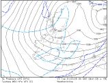
All weekend we've been tracking the position of an area of low pressure as it moves south across the British Isles and Ireland through Tuesday and Wednesday. Monday mornings forecast now brings the low southwards through the country during Tuesday.
Now, most of the precipitation within the low is going to be falling as rain across the lower levels of Scotland today, although it will be as snow over the hills. The rain moves south this afternoon with sleet across Northern Ireland and northern England and snow over the Pennines.
The real fun and games begin tonight as the band of precipitation reaches Wales, the Midlands and East Anglia. Colder air through these regions will enable sleet or snow to fall, with the highest risk of accumulations likely across the eastern Midlands and East Anglia. This is based on the precipitation not being very heavy. However, there is a risk of the low deepening further than we expect, and if this happens more persistent precipitation may fall which could lead to more widespread snow through the Midlands and southern England.
 There are also complications for southwest England during Tuesday. As the rain reaches here there are indications that it may turn heavier and could bring a period of snow through Tuesday afternoon and night.
Frequent snow showers are expected across Scotland and northeast England through Wednesday and it will be feeling cold here.
We are also keeping an eye on conditions through Wednesday as the low pressure becomes slow moving off the south coast. There is a low risk of some wintry conditions across southern and central England with the potential for disruption.
Simon