WeatherOnline Summer Heat Feature
Current Outlook
 Current Heatwave Prediction
High pressure will build from Saturday onwards across England and Wales, extending from the Azores high to our south-west. The pressure gradient will still be sufficiently high across western parts however, to allow Atlantic weather fronts to brush north-western parts during the weekend. By the end of Sunday however, the high pressure area is expected to become more extensive across all parts. In terms of weather, conditions will become brighter over the weekend, although the extreme south and north-west will see conditions slow to improve. Long sunny spells elsewhere will left temperatures to highs of 25C across central England by Sunday.
 The high pressure centre is expected to drift into the North Sea during Monday and Tuesday, encouraging a more prominent south or south-east flow. Sunshine amounts will vary across the country, due to advecting areas of cloud. Temperatures will reach highs of 29C on Tuesday across central parts, and even 24C into Scotland. As is commonplace at this time of year, high temperatures across France may well give rise to a thermal low by Wednesday. This may travel erratically northwards at times, bringing the risk of scattered heavy showers across the Channel Isles and the extreme south of England. For the most part however, Wednesday and Thursday will remain hot and settled across most parts, with sunny spells lifting temperatures to 31C in the south, 25C in the north.
 Friday and the weekend are currently rather uncertain, although it is expected to remain very warm or hot. The progression of thundery activity into this period at present in eliminated, as we believe high pressure will maintain overall control across the UK. During Saturday, the high looks set to be reinforced by the Azores high from the south-west. Top temperatures during this period will stay in the high twenties across England and Wales, low to mid twenties elsewhere. Please note that this forecast is based on current analyses, and conditions and models may alter in time, so further heatwave updates will encompass these. To see the current forecast for early next week, you can view the weekly forecast page. The following links provide forecast charts for next week:
Next Week's Weather : UK, Ireland
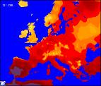
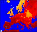
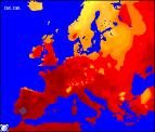
Predicted Temperatures : 2m Max, z T850hPa
NH Pressure Charts: NHSLP
Chance Of Rain? : Precip (mm), CAPE
Expert Weather Maps : here
Model Runs : here