Records Are Smashed! Remaining Settled This Week!
Report & Forecast
 The Heatwave So Far...
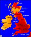
It's official! After a much publicised build-up, Sunday saw the heat rising across many parts, with south-east England seeing the highest temperature since records began. All eyes were on the mercury during the day, and by early afternoon the record of 37.1°C, measured in Cheltenham in 1990 had been reached at London Heathrow. However, this was not the end to the stifling heat, as Gravesend in Kent rose even higher, with a final maximum of 38.1C, that's almost 101°F! This is the first time since records began that temperatures have reached three figures (°F) in the UK. However, as the south-east sizzled, parts of Northern, Central England and Wales were battered by intense thunderstorms. Reports of hail and local flooding were received, after storms developed over North Wales during the morning, moving north and east during the day. In Birmingham, two factories caught fire after being struck by lightning, and in the same region 14 people were slightly hurt after a lightning strike at a football match. Parts of North-east England saw almost 2 inches of rain falling in less than an hour, and in Wales many roads were blocked as water-leaden trees began falling. After an extremely eventful day, and a week of very high temperatures, the cold front responsible for yesterday's thunderstorms is set to bring something of a change over this coming week.
 This Week : Cooler & Fresher, Remaining Warm & Sunny Until Weekend
The cold front will clear south-east by the end of Sunday, then all parts will see a ridge of high pressure building in from the south-west during the week. Sunny spells will continue, although temperatures will be several degrees lower than last week. Highs are expected consistently through the week of between 23°C and 26°C in the south, more like 20°C to 23°C in the north. There is the potential for conditions to become more unsettled by the weekend as weather fronts nudge in from the west, but this will be a slow process, and may take until Sunday for all parts to see the cloud and rain.
To see the general weekly forecast, you can view the weekly forecast page. The following links provide forecast charts for the coming week:
Next Week's Weather : UK, Ireland
Predicted Temperatures : 2m Max, z T850hPa
NH Pressure Charts: NHSLP
Chance Of Rain? : Precip (mm), CAPE
Expert Weather Maps : here
Model Runs : here