Long-range Outlook: 13/05/04 - 18/05/04
A taste of summer coming up!
Click here for details of the weather over the next few days.
Please note that forecasting beyond five days is notoriously difficult, and small errors at short-range can lead to large deviations further in time. Our longer-range forecasts are based on the most accurate weather data available at the time, but alterations may be required as the period progresses. Please check back regularly for the most up-to-date forecast run.
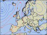
Thursday 13/05/04 to Friday 14/05/04
Most of England, Wales and Ireland will be enjoying a return to summer conditions on Thursday, with plenty of sunshine. Although temperatures won't be record-breaking, it will feel warm with only light and variable winds. Scotland and Northern Ireland won't be as fortunate however, as weather fronts give a good deal of cloud. Outbreaks of rain will even develop, but these will mostly be in north-west Scotland and the far north of Northern Ireland. On Friday, the cloud will persist across the same areas, although it will be very fragmented and any rain left on it will largely peter out. Northern England can expect more in the way of cloud as a result, and this will spread to north Wales in the afternoon. The rest of England, Wales and Ireland will have another mostly fine day with variable amounts of cloud and plenty of sunny spells. Feeling warm in light winds.
 Saturday 15/05/04 to Sunday 16/05/04
On Saturday, the fine and settled conditions across England and Wales will remain with very light west to north-westerly winds. Any remaining cloud left on Friday's weather front will have mostly cleared, so much of Northern Ireland and northern England will join in the sunny weather. There may be a scattering of mostly light showers however, and these will develop more especially across the Highlands of Scotland during the afternoon. High pressure looks set to stay in control of the UK's weather into Sunday, if anything becoming positioned right over the country. With southerly winds developing across Ireland, Northern Ireland and western parts of the mainland, temperatures look set to increase somewhat in these areas. Elsewhere, it will be a little cooler, but with all the sunshine around and light winds it will feel pleasantly warm.
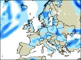 Monday 17/05/04 to Tuesday 18/05/04
Monday looks like becoming warmer still based on current models, with southerly winds pumping warm air across the country. Southern England and parts of Wales will have the highest temperatures, helped by long spells of sunshine. It will be largely dry with sunny spells elsewhere as well, as high pressure continues to dominate. However, as low pressure nears from the west, scattered showers will break out over Scotland, and particularly across Ireland later with the risk of thunder. That trend to more unsettled conditions will continue into Tuesday, with thundery outbreaks of rain across much of Ireland and Scotland, moving into other western parts of the UK during the afternoon. Central and eastern parts of England will have another dry and very warm day however.