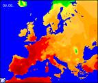
Long-range Outlook: 05/06/04 - 10/06/04
Sunny and very warm at first, breaking to rain and thunder later.
Click here for details of the weather over the next few days.
Please note that forecasting beyond five days is notoriously difficult, and small errors at short-range can lead to large deviations further in time. Our longer-range forecasts are based on the most accurate weather data available at the time, but alterations may be required as the period progresses. Please check back regularly for the most up-to-date forecast run.
Saturday 05/06/04 to Sunday 06/06/04
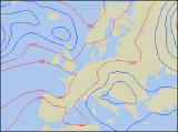
The previous forecast for the return of summer is holding true for on Saturday, but more especially for England, Wales and the Rep. of Ireland. High pressure over southern England will give these parts a glorious day with plenty of sunshine and temperatures in the low twenties Celsius. A different story for Northern Ireland and Scotland, with a fresh wind, cloudier skies and occasional rain or drizzle. Some sheltered eastern parts even here should have some brightness however. On Sunday, northern parts of the UK will remain rather cloudy, but any rain will die out to leave a few sunny spells later. It will feel warmer here as the winds ease considerably. England, Wales and the rest of Ireland will have another fine and very warm day, with the best of the sunshine across parts of the south. Winds will be light and variable across these parts, but later an easterly breeze will develop through the English Channel.
 Monday 07/06/04 to Tuesday 08/06/04
The start of the new week will see little change across England and Wales, with more sunshine on Monday. With a southerly wind, temperatures will begin to creep into the mid to high twenties Celsius in southern parts. Scotland will also join in the summery conditions, with some fine sunshine here too and pleasant temperatures. Ireland and later parts of Northern Ireland will be humid with more cloud around, and the risk of scattered heavy showers towards evening. Conditions look set to become even warmer on Tuesday, and in parts of south-east England there is the chance that thirty degrees Celsius may be reached. However, it will begin to feel rather humid everywhere with a southerly breeze, and as ever more cloud across Wales, Ireland and south-west England may produce some afternoon showers and thunderstorms. Towards evening, isolated thunderstorms may drift northwards across the Channel into parts of southern England.
 Wednesday 09/06/04 to Thursday 10/06/04
The warm, settled conditions currently look like breaking country-wide during Wednesday, with outbreaks of heavy rain slowly spreading from the west. Some hefty downpours are likely, with scattered thunderstorms breaking out ahead of the main rain. Much of Ireland, and later Wales and western parts of Scotland and England will become brighter, but also much fresher. Thunderstorms in the east may last well into the night, and it will remain humid in the south-east. On Thursday, Scotland will have a rather cool day with outbreaks of rain. Ireland will be mostly dry but there will be a good deal of cloud around. After a grey start, England and Wales will brighten up with some warm sunshine, but outbreaks of rain will move up from the south to affect many southern parts in the afternoon. Fresher everywhere.