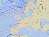
Long-range Outlook: 04/06/05 - 09/06/05
Rain/showers at first. Fine into next week.
Click here for details of the weather over the next few days.
Please note that forecasting beyond five days is notoriously difficult, and small errors at short-range can lead to large deviations further in time. Our longer-range forecasts are based on the most accurate weather data available at the time, but alterations may be required as the period progresses. Please check back regularly for the most up-to-date forecast run.
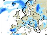
Saturday 04/06/05 to Sunday 05/06/05
Most places will start the weekend with some sunny spells during Saturday. However, with a cool north-westerly airflow, scattered showers will break out too. Some of these showers will be heavy, especially across Scotland and north-west England, where they will be more frequent. There could even be some more persistent rain in eastern areas for a time. Later in the day, drier weather will spread across Ireland, south-west England and south Wales. Feeling rather cool in the brisk north-westerly wind later. Sunday will start fine with lots of sunshine across much of England, Wales and Scotland, and across eastern areas it should remain dry and fine all day. However, low pressure in the Atlantic will soon throw weather fronts eastwards, with heavy spells of rain affecting Ireland and Northern Ireland during the morning. These will spread across Wales, much of western England and also western Scotland through the afternoon, still with some heavy bursts. Most places will be fairly warm, especially in the south-east where the sunshine persists.
 Monday 06/06/05 to Tuesday 07/06/05
Monday will start rather wet across England and Scotland, but cloud and rain will become restricted to eastern areas during the afternoon. Across most of Ireland, together with Wales, and later western parts of England, there will be some sunny spells and just a scattering of showers. Western Scotland will also become brighter through the afternoon, although scattered showers could be heavy in places too. Winds will be very light everywhere, and across western areas it will feel pleasantly warm in the sunshine. Tuesday looks like being the start of a change in our weather, as high pressure nudges in from the west. This will give most of the UK a dry day with lots of sunny spells. It will also become warm in many areas, perhaps even very warm across the south through the afternoon. However, this could be enough to trigger an isolated shower or two. Winds will be generally light, although they will be brisk in the north at first.
 Wednesday 08/06/05 to Thursday 09/06/05
Wednesday looks set to be a glorious day across the entire UK and Ireland, with high pressure firmly in control. It should be mentioned that confidence is only moderate at the moment, and the intensity and position of the high will dictate just how sunny the weather is. However, based on current predictions, everywhere will have sunny spells, and should become very warm during the afternoon. Highest temperatures across southern areas could reach the high 20's Celsius through the afternoon, with the low 20's Celsius in the north. Thursday will remain under the influence of high pressure, but weak weather fronts stretching through central parts will give rather more in the way of cloud at times. However, it should remain dry, and most places will have some warm sunshine. Please check back for the next forecast update, to firm up on details for the potential fine weather later next week.