Weekly Outlook : 01/08/03-07/08/03
Briefly Cloudy & Damp, Then Warm & Sunny
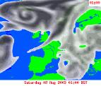 Friday 01/08/03 to Saturday 02/08/03
Weather fronts pushing gradually south-eastwards will give many parts a cloudy morning on Friday. Across England and Wales, outbreaks of mainly light rain will spread from the west, becoming confined to the south coast during the afternoon. At the same time Ireland, Northern Ireland and Scotland will become much brighter with long sunny spells, and one or two showers. This brighter weather will extend to most parts by evening, but southern districts are expected to remain cloudy overnight and into Saturday. High pressure building across the country on Saturday, so most parts having a sunny day with only patchy cloud. South-eastern parts will take until afternoon to brighten up however. Light winds across most parts allowing it to feel pleasantly warm, whereas stronger winds in the north-west will take the edge off the temperatures.
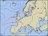 Sunday 03/08/03 to Monday 04/08/03
High pressure gearing up during Monday, as the start of much warmer conditions begins. All of mainland UK will have a bright day, with long sunny spells for many. Coupled with light south-easterly winds, temperatures will reach the mid twenties Celsius across central parts during the afternoon. The exception will be western parts of Ireland, where cloud will increase with the chance of some light rain during the afternoon. This will spread to western Scotland for a time overnight, but will clear during Monday morning. Elsewhere another bright start, and rapidly becoming very warm for many parts. Sunshine lasting into the afternoon almost everywhere, although there is the outside chance of a shower in the south-west by evening.
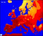 Tuesday 05/08/03 to Thursday 07/08/03
Midweek is set to see anticyclonic conditions dominate, thus a heatwave is very much on the cards. Tuesday will see many parts basking in long sunny spells with temperatures reaching the high twenties Celsius in central parts. There will be cloud around at times, and at present it is not possible to speculate exactly where. The same can be said about Wednesday, and even Thursday with the possibility of exceeding 30C in places. Models are currently suggesting that conditions may become a little more unsettled in the south-west and Channel Isles at times, with a thundery shower or two. This however is very uncertain at the moment, so further detail on this will be given in the next forecast update.