Weekly Outlook : 01/09/03-07/09/03
High Pressure Dominating. Warm & Sunny Until Weekend.
 Monday 01/09/03 to Tuesday 02/09/03
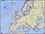
Although the summer months may be considered behind us, summer looks set to make a return across many parts this week. Monday morning will be bright and breezy across many parts, the breeze rather strong along eastern coasts. Into the afternoon, cloud will bubble up across the country, but still with plenty of sunny spells. North-western parts will become rather more cloudy, perhaps with a little light rain later. Feeling pleasant in most parts, but tempered by the stiff northerly wind. Overnight and into Tuesday, clear skies will allow it to become rather chilly, but will result in a sunny start. Cloudier skies across Scotland and Northern Ireland will move southwards through Northern England and North Wales during the early afternoon, but this gradually breaking up. With northerly winds easing, it will feel warmer in all parts, with highs possibly reaching the low to mid twenties Celsius across central and southern England under high pressure.
 Wednesday 03/09/03 to Thursday 04/09/03
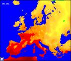
High pressure well in charge by Wednesday, with many parts enjoying long sunny spells and warm temperatures. These will range from the high teens to low twenties Celsius across northern parts, the mid twenties across central and southern parts. Winds will be light and from the south-east, although becoming stronger across Ireland later. Another fine day for most on Thursday, at least to begin with. A stronger south-east flow will allow temperatures to nudge up across the south, with highs possibly reaching 27C in one or two spots. A different story for the extreme west of Ireland, Northern Ireland and Scotland, with cloudier skies and the odd spot of rain. There is the chance also later in the day of a sharp shower across south-eastern parts, but most places will end the day warm and sunny.
 Friday 05/09/03 to Saturday 07/09/03
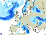
Continuing warm and settled in many parts of the country on Friday, with temperatures once more in the mid twenties Celsius for many. Once again the exception will be the extreme west, where trailing weather fronts will bring more in the way of cloud and occasional showery rain. The weekend looks like becoming more unsettled from both the west and the south. Although confidence is only about 70% at present, Saturday should see showery rain spreading northwards during the morning across central and eastern parts, while at the same time cloud and patchy rain spreads eastwards across Ireland. Scotland will hang on to brighter skies with sunny spells, but by Sunday all parts are expected to see spells of rain from time to time. It should remain warm however despite the unsettled conditions, with winds mostly light. Further weekend details in the next forecast update.