Long-range Outlook: 05/03/05 - 10/03/05
Staying cold and wintry in the east.
Click here for details of the weather over the next few days.
Please note that forecasting beyond five days is notoriously difficult, and small errors at short-range can lead to large deviations further in time. Our longer-range forecasts are based on the most accurate weather data available at the time, but alterations may be required as the period progresses. Please check back regularly for the most up-to-date forecast run.
Saturday 05/03/05 to Sunday 06/03/05
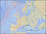
Saturday originally looked like the start of a return to milder weather, but current indications are suggesting that it will remain wintry in places. High pressure to the west and a small area of low pressure close to eastern England will maintain a cold north-easterly wind across all parts. Showers or longer spells of rain or sleet will fall as snow across eastern England, and over south-east England in particular further accumulations are possible. The best of any drier, brighter weather will be across Ireland, Northern Ireland and western Scotland, but it will feel cold everywhere. On Sunday, high pressure will begin to take hold across most of Scotland, Ireland and western parts of England and Wales, giving sunny skies after a frosty start. Cloud will tend to persist in eastern parts of England, with north-easterly winds blowing in occasional showers of rain or sleet, with snow once again above about 150m. Staying cold in eastern areas, but it will feel more pleasant in the west with lighter winds.
 Monday 07/03/05 to Tuesday 08/03/05
The synoptic setup will remain very similar on Monday, with a large area of high pressure over western parts of the UK, and low pressure over the North Sea. With light winds, much of the western side of the UK, including Wales, western England and western Scotland will be dry with sunny spells. Ireland will also have another largely fine day after a morning frost. Cloud will continue to plague eastern England, and perhaps eastern Scotland, with occasional showers of rain or sleet. Slightly less cold, but still chilly here in the northerly wind. Another fine day is expected for many on Tuesday, with variable cloud and sunny spells stretching from north-west Scotland, through north-west England and Wales, across into central southern England. Ireland and Northern Ireland will also stay fine, although overnight frost will be slow to clear. The familiar tale of thickening cloud and occasional wintry showers will continue along eastern coastal areas of Scotland and England, from Aberdeenshire to Kent.
 Wednesday 09/03/05 to Thursday 10/03/05
Our large area of high pressure may try and work slightly further eastwards on Wednesday, leading to subtle changes across the UK. After the sunny skies of late, western parts of Ireland will cloud over with drizzle as a south-west wind picks up. Wintry showers in eastern England will become increasingly confined to the south-east, mostly falling as rain too. Elsewhere across the UK, it will be mainly dry with some sunshine after a chilly start. There will be very little in the way of change on Thursday, although winds across northern areas are expected to turn more north-westerly. As a result, there will be a lot more cloud in the north with occasional rain, whilst the south stays mainly dry and chilly. The weather during the course of next week will rely heavily on very small changes in the position of high pressure. As a result, please check back for further forecast updates, as details develop.