Long-range Outlook: 06/09/04 - 11/09/04
Settled and warm at first. Increasingly cool later with rain for some.
Click here for details of the weather over the next few days.
Please note that forecasting beyond five days is notoriously difficult, and small errors at short-range can lead to large deviations further in time. Our longer-range forecasts are based on the most accurate weather data available at the time, but alterations may be required as the period progresses. Please check back regularly for the most up-to-date forecast run.
Monday 06/09/04 to Tuesday 07/09/04
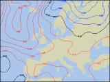
The start to next week is looking promising at present, with high pressure on the scene for Monday. This will give much of Scotland, Ireland and Northern Ireland fine, sunny conditions, with only a gentle breeze. Although mostly dry and bright across England and Wales too, northern parts will have more cloud around with the risk of showery rain at first. However, this will die away later, leaving late sunny spells. After a chilly start to Tuesday, perhaps with patchy ground frost in the north, many places will have another dry day as high pressure remains in control. Once again, there may be rather more cloud around across central and southern parts of England, perhaps with the odd shower. However, most places even here will remain dry and bright. Later in the afternoon, cloud will thicken up across western parts of Scotland and Northern Ireland, with the risk of rain here by dusk. Feeling pleasantly warm in most places with generally light winds.
 Wednesday 08/09/04 Thursday 09/09/04
The high pressure will still be here on Wednesday, but residing to the west of the UK. This will encourage rather more of a northerly breeze across many places, making it feel rather cool, especially in north-east Scotland and north-east England. Central and southern England, Wales and Ireland will be mostly dry with lots of pleasant sunshine. However, across Northern Ireland, Scotland and the rest of England, it will be rather cloudy with showery bursts of rain in places. The forecast is a little uncertain for Thursday at present, but it does look as if the high pressure to the west of the UK will remain put, and the northerly flow will become more pronounced. In these situations, the best of the sunshine will be further south and west, so Ireland, Wales and south-west England will have the more pleasant conditions. Rather more cloud elsewhere, and close to the east coast outbreaks of rain will come and go. Fresh northerly winds here making it feel much cooler.
 Friday 10/09/04 Saturday 11/09/04
There will be little change in the synoptic setup on Friday, with high pressure to the west and low pressure to the east continuing to bring in a straight run of northerly winds. It will feel fairly cool in all parts, and especially chilly across Scotland and eastern parts of England. Here, northerly winds will be strong at times, with a good deal of cloud giving outbreaks of showery rain. The best of the sunshine will be out west once again. The winds are expected to shift more north-westerly on Saturday, so the rain across eastern parts of England should clear into the North Sea. Most of England and Wales, along with Ireland will be dry with some sunshine. However, Scotland and north-east England will still be at risk from some blustery showers. The forecast for Sunday is currently looking very unsettled indeed with rain for all. However, please check back for further details on next week and beyond.