Long-range Outlook: 06/09/05 - 11/09/05
Mixed next week. Warmer next weekend.
Click here for details of the weather over the next few days.
Please note that forecasting beyond five days is notoriously difficult, and small errors at short-range can lead to large deviations further in time. Our longer-range forecasts are based on the most accurate weather data available at the time, but alterations may be required as the period progresses. Please check back regularly for the most up-to-date forecast run.
Tuesday 06/09/05 to Wednesday 07/09/05
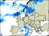
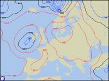
After the warm conditions over the weekend, Tuesday will be much cooler with low pressure across the UK. Showery bursts of rain will be fairly widespread across Scotland, England and Wales, although eastern and south-eastern England may become drier and brighter. Ireland and Northern Ireland will have some sunny spells, but showers will break out, especially in the afternoon where there will be a risk of thunder. Feeling pleasant in the sunshine with light winds, although it'll be cooler when the showers come along. On Wednesday, conditions will be much drier across England and Wales, with occasional sunshine and only very isolated showers. The showers will be a little more widespread across the far north of England, together with much of Scotland, although even here some sunny spells are likely. Ireland and Northern Ireland should start bright, and across eastern areas it will remain bright all day. It will be a different story in the west though, as Atlantic weather fronts spread cloud and rain slowly in from the west during the afternoon. Temperatures around average across the UK and Ireland.
 Thursday 08/09/05 to Friday 09/09/05
On Thursday, a weakening band of cloud and rain will move slowly east across England and Wales, never quite reaching the south-east. This cloud will slowly break up, and many areas will become brighter by evening. Early rain will clear from Ireland and southern Scotland, and it will become dry for a time. However, heavy and persistent rain across Northern Ireland and northern Scotland throughout the day will spread slowly south and east across southern Scotland and Ireland later. South-west winds will freshen in the north and west, but winds will remain light elsewhere. High pressure is expected to build up from the south during Friday, although the northward extent of this ridge is currently uncertain. However, it does look as if southern England, the Midlands and south Wales will be dry during Friday with some warm sunny spells. Northern England and north Wales will have more cloud around, perhaps with a few showers. These conditions will extend across Ireland, although rain could be heavier here. For Northern Ireland and Scotland, it will be cool and breezy, but it will be dry with sunshine.
 Saturday 10/09/05 to Sunday 11/09/05
The ridge of high pressure across England on Friday is expected to build northwards across the rest of the UK during Saturday. It won't be wall to wall sunshine though, as there will be quite a lot of cloud around. That said, England, Wales and Scotland will be pleasantly warm with some periods of sunshine. With weather fronts close to western areas, Northern Ireland and the Irish Republic may have patchy light rain in western areas. Eastern parts should be dry, with some brightness in sheltered northern areas. Things are expected to start hotting up on Sunday, as south-easterly winds draw up very warm air off the continent. Most of the UK will be dry with some sunshine, the best of which will be in eastern and southern areas. Once again, western parts of Ireland, and perhaps northern Scotland, will be cloudier with hill and coastal drizzle. However, the return of warm weather is currently a long way off, so please check back for further forecast updates.