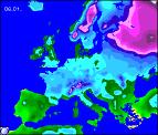
Long-range Outlook: 07/01/06 - 12/01/06
A Mild vs Cold Battle.
Click here for details of the weather over the next few days.
Please note that forecasting beyond five days is notoriously difficult, and small errors at short-range can lead to large deviations further in time. Our longer-range forecasts are based on the most accurate weather data available at the time, but alterations may be required as the period progresses. Please check back regularly for the most up-to-date forecast run.
Saturday 07/01/06 to Sunday 08/01/06
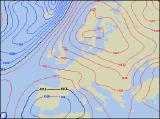
By Saturday, a large anticyclonic block will be firmly established over Scandinvia. This will have two effects for the UK. Firstly, it will give a cold south-easterly flow across most places, keeping weather fronts at bay out to the west. Secondly, the exact location of the high will determine the precise weather expected, and as a result, it will make detailed long-range weather forecasting very difficult. On Saturday, fresh southerly winds will blow in cloud, rain and milder air across the western half of Ireland and Northern Ireland. The rest of Ireland will be dry but cloudy. For a large part of England, Wales and western Scotland, it will be dry with occasional brightness after a frosty start, but it will be cold. However, in eastern England, and perhaps along the south coast. we're expecting scattered light showers of sleet or snow. Winds will turn more southerly on Sunday, and a spell of rain and sleet, possibly snow too, will move north across England. The western half of England though, along with Wales, Scotland and the east of Ireland will be dry and bright. However, more rain will affect the west of Ireland.
 Monday 09/01/06 to Tuesday 10/01/06
The colder air is expected to just about hold on across eastern England on Monday, with cloud and scattered wintry showers. Elsewhere, a series of Atlantic weather fronts will spread north-east across the country, bringing a good deal of cloud and rain. Some of this could fall as sleet or wet snow across north-east England for a time. Behind the rain across Ireland and Northern Ireland, it will turn much milder with a few showers. However, winds will reach gale force during the afternoon. Models are suggesting a return to milder air for most places on Tuesday, with strong south-westerly winds affecting the UK and Ireland. However, the south-east of England will probably remain chilly after an early frost. As well as the wind, heavy and persistent rain will affect much of Northern Ireland and Scotland, with lighter, more patchy rain across the Irish Republic and northern England. For Wales and remaining parts of England, there will be a lot of cloud, but it should stay dry with some brightness in the east.
 Wednesday 11/01/06 to Thursday 12/01/06
The current details for Wednesday and Thursday are rather sketchy, due to the uncertainties over this coming weekend. Model output is indicating that the UK and Ireland will remain in a generally mild west to south-westerly wind, with cloud and rain affecting northern and western parts of the country. That said, the east and south will see temperatures slightly below average, with a night frosts quite likely. Towards the end of Thursday, there are signs that high pressure to try to ridge back in from the south-east, although confidence of this is currently very low. Please check back for further forecast updates, regarding next week's weather.