Weekly Outlook : 04/04/03-10/04/03
High Pressure In Charge- Variable Cloud, Mostly Dry
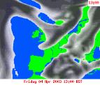 Friday 04/04/03 to Sunday 06/04/03
After our brief unsettled spell, high pressure is back on the scene and will dominate the weather through the coming weekend. There will be rather a lot of cloud around however, and Friday is no exception. Weak fronts straddling the far north and south-east may even produce the odd spot or rain or drizzle, but central and western parts will see some sunshine. Brightness will increase through Saturday and into Sunday, with less in the way of cloud except perhaps the far north east. As winds swing around to the south-east from the north-east, temperatures will rise from highs of 9°C to 13°C on Friday, to 12°C to 16°C on Sunday. Night-time temperatures will be remain cool however, with a touch of frost likely in parts.
 Monday 07/04/03 to Tuesday 08/04/03
Confidence is high that our anticyclone will remain a dominant influence on our weather during Monday and Tuesday, however fronts will prove difficult to forecast. It seems very likely that weak fronts will spread cloud into north-western parts late on Monday after a bright day. Elsewhere will see long sunny spells after early morning mist, and it will become pleasantly warm away from the coasts. The fronts will make stately progress into central parts during Tuesday, mostly just bringing a good deal of cloud and the odd spot of light rain. Turning brighter if slightly cooler in the north, and staying fine in the far south.
 Wednesday 09/04/03 to Thursday 10/04/03
High pressure looks set to re-establish from the south-west, becoming a strong force in the UK's weather for some time. Many places will have long sunny spells, once any cloud has cleared away from southern and eastern parts. Overnight temperatures will fall but not enough for much in the way of frost. The end of the week will continue fine and settled, with the prospect of significant rain in the foreseeable future looking unlikely.