Long-range Outlook: 07/07/05 - 12/07/05
Rather cool and changeable.
Click here for details of the weather over the next few days.
Please note that forecasting beyond five days is notoriously difficult, and small errors at short-range can lead to large deviations further in time. Our longer-range forecasts are based on the most accurate weather data available at the time, but alterations may be required as the period progresses. Please check back regularly for the most up-to-date forecast run.
Thursday 07/07/05 to Friday 08/07/05
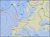
Thursday will be very unsettled, as a deepening low pressure runs southwards through the North Sea. This will drag in cool north-westerly winds across the UK, particularly strong along the coasts of eastern England and eastern Scotland. There will also be a lot of cloud, producing rain across most of Scotland and England, heaviest in the east. The rain will be lighter across Wales and south-west England, whilst the best of the drier and brighter conditions will be across Ireland and Northern Ireland. Cool everywhere, but more so across Scotland and England. On Friday, the low will gradually move away eastwards, taking with it most of the rain and strong winds. However, a cool north-westerly will persist across most of the UK, allowing a few heavy showers to develop across central and eastern areas. There will be some sunny spells across most places too, and in Wales, western Scotland and south-west England it will become dry through the afternoon. Once again, the best of the sunny spells and fewest showers will be across Ireland and Northern Ireland, and with lighter winds it will be warmer here.
 Saturday 09/07/05 to Sunday 10/07/05
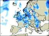
On Saturday, with a ridge of high pressure trying to build in across the south, it will be the turn of eastern areas of England and Scotland to have the driest conditions, with some sunny spells. Out to the west across Ireland, weak weather fronts will spread cloud and occasional rain eastwards through the day. This will reach western Scotland, north-west England and Wales during the afternoon. Quite warm in the sunshine further east, but rather cool in the cloudier west. The synoptic situation for Friday is looking very complicated at present, with several slack areas of low pressure encircling the UK and Ireland. As a result, most places can expect rain or showers, some heavy with at risk of thunder. The best chance of any sunshine will be in coastal areas, and also in south-east England which will still remain under the influence of continental high pressure.
 Monday 11/07/05 to Tuesday 12/07/05
Remaining generally unsettled on Monday, with low pressure never too far away. Current indications suggest that rain will spread from west to east across most of Ireland, Wales, together with central and southern England during the day. It should be a better day for Northern Ireland, northern England and Scotland, with sunny spells and just a scattering of showers. However, rain will extend even to these areas during Tuesday, as low pressure deepens right over the UK. Any areas to see sunny spells between the showers will be amongst the lucky minority, and it will feel rather cool with a fresh north-westerly wind developing once again. For more detail on next week's weather, please check back for further forecast updates.