Long-range Outlook: 08/01/05 - 13/01/05
Wet & windy at first. Hints of settled weather later.
Click here for details of the weather over the next few days.
Please note that forecasting beyond five days is notoriously difficult, and small errors at short-range can lead to large deviations further in time. Our longer-range forecasts are based on the most accurate weather data available at the time, but alterations may be required as the period progresses. Please check back regularly for the most up-to-date forecast run.
Saturday 08/01/05 to Sunday 09/01/05
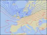
A very deep area of low pressure to the north of Scotland will be in control of our weather during Saturday. Westerly winds around the low will give a risk of gales or even severe gales across Scotland, Northern Ireland and northern parts of England, although it will be very windy everywhere. A spell of heavy rain will sweep eastwards, clearing eastern England during the afternoon. This will be followed by squally showers of rain and hail, with thunder likely. More persistent rain will return to Scotland too after a briefly brighter start. On Sunday, another low will roll in off the Atlantic, joining forces with the low to the north of Scotland. Winds will become south-westerly, and the threat of gales will transfer to southern parts of Ireland, south Wales and south-west England. England, Wales and Scotland will have a sunny morning, but rain across Ireland will sweep eastwards in the afternoon, becoming very heavy in places. It will become very mild through the day.
 Monday 10/01/05 to Tuesday 11/01/05
It will remain very windy during Monday, with a risk of gales around Irish Sea coasts, and along the west coast of Ireland. The winds will turn more westerly through the day, but not before a band of heavy rain has swept eastwards. Some very gusty winds are likely as the rain moves through, although it will have cleared all but eastern England by the end of the afternoon. Thereafter, there will be some sunny spells, but also frequent showers, heavy and wintry across the north. As the low to the north tracks eastwards on Tuesday, winds will turn around to a north-westerly direction. This means it will turn colder across most places, but particularly across the north-west. England and Wales will have a dry and sunny morning. However, Northern Ireland and Scotland will start wet with heavy rain, turning to snow over the hills. This will spread southwards through Ireland and across England and Wales. Showers following this in the north will fall as sleet and snow, even at low levels.
 Wednesday 12/01/05 to Thursday 13/01/05
Fortunes look like changing on Wednesday across England, Wales and southern parts of Ireland. An area of high pressure is expected to build up from the near continuent, resulting in a dry day with plenty of sunshine. For northern England, Northern Ireland and Scotland, it will be cloudier with a risk of rain and drizzle. Feeling rather chilly in the south, although with lighter winds it will still be pleasant in the sunshine. This high is expected to stay put during Thursday, resulting in another dry and fine day for England and Wales. There will be a widespread frost both early and late though. Fresh south-westerly winds will blow in a lot more cloud elsewhere in the UK and Ireland, with coastal rain and drizzle for much of the day. As ever, please check back for forecast updates.