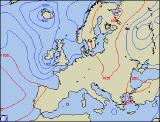
Weekly Outlook : 05/09/03-11/09/03
Becoming Unsettled From West. Low Pressure, Wind & Rain Next Week.
 Friday 05/09/03 to Saturday 06/09/03
High pressure will just about keep hold across central and eastern England during Friday, with sunny spells and warm temperatures. Some parts of eastern England will see highs around 25C during the afternoon. Out to the west, across much of Ireland, Northern Ireland and western Scotland, a much cloudier day with rain spreading slowly east. This will reach western parts of the mainland by evening, although much of it light in the south. Overnight, the odd sharp shower may break out across southern and eastern parts. By Saturday morning cloud and remaining light rain should clear from eastern England and Scotland, then most parts will be dry with good spells of sunshine due to a small ridge of high pressure. It will however feel much cooler and towards evening the extreme west will see cloud increasing and winds becoming strong, heralding a major change in our weather.
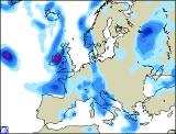 Sunday 07/09/03 to Monday 08/09/03
Sunday will see the first major depression of September, with spells of heavy rain and strong winds for most. During the morning, western parts will bear the brunt of the unsettled weather, with several hours of heavy rain and winds touching gale force southerly through the Irish Sea. After a bright morning remaining parts of England and Wales will cloud over, with rain spreading east during the afternoon. Little change during the evening and overnight, with rain setting in across central and eastern parts, while showers spread across western regions. By Monday morning, the more persistent rain will be confined to the east, whilst elsewhere morning sunshine will give way to blustery showers. These will gradually die out during the afternoon as a weak ridge of high pressure builds from the west, but eastern parts will remain wet with rain or showers for much of the day. Feeling cooler with all this weather activity around.
 Tuesday 09/09/03 to Wednesday 11/09/03
There is the chance that eastern parts may have a largely cloudy morning on Tuesday, but for remaining parts it should be a bright, dry start. This won't last across Ireland however, as we're expecting another low pressure system, the remnants of hurricane Fabian to spread cloud and rain eastwards by midday. This rain will quickly spread to remaining parts of England and Wales during the evening and overnight. Wednesday should see another brief drier interlude, with sunny spells, however for western parts it looks like a repeat performance with further wind and rain spreading off the Atlantic. In summary, although exact timing is difficult at present, the first part of next week is set to be very unsettled, with our first return to Atlantic zonality for many months.