Long-range Outlook: 08/10/05 - 13/10/05
Autumnal. Windy Weekend.
Click here for details of the weather over the next few days.
Please note that forecasting beyond five days is notoriously difficult, and small errors at short-range can lead to large deviations further in time. Our longer-range forecasts are based on the most accurate weather data available at the time, but alterations may be required as the period progresses. Please check back regularly for the most up-to-date forecast run.
Saturday 08/10/05 to Sunday 09/10/05
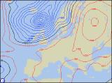
After the relatively settled start to the week, things will go rapidly downhill by the end of the week and into the weekend. On Saturday, low pressure to the north of Scotland will drag an active cold front eastwards across the UK, giving a spell of heavy rain to all areas. The rain will clear to blustery showers and sunny spells, especially across Scotland and Northern Ireland, where the westerly wind will reach gale force around the coast. Turning much cooler after a fairly mild morning. Sunday is currently looking potentially stormy for northern parts of the UK, as an intense Autumn storm passes over northern Scotland. Westerly winds will routinely reach gale force across Northern Ireland and Scotland, with severe gales possible across northern Scotland. Although it's a long way off at the moment, we are watching for the possibility of damaging gusts of wind in northern Scotland. As well as the wind, which will be strong across the rest of the UK too, there will be a lot of cloud with outbreaks of rain, always heaviest across the north and west. South-east England will remain dry until evening.
 Monday 10/10/05 to Tuesday 11/10/05
By comparison with Sunday, Monday will be a much quieter day, with lighter northwest winds. However, heavy bursts of rain will continue to affect England and Wales, only slowly clearing eastwards through the afternoon. Ireland and eastern Scotland, after a wet start, will be mainly dry with some sunny spells. Sunny spells too across western Scotland and Northern Ireland, but also a rash of heavy showers, perhaps with hail and thunder. Much cooler in the northwest winds once again. After a chilly start to Tuesday morning, with a ground frost in sheltered northern areas, much of the UK and Ireland will have a dry day with some sunny spells. The northwest winds will still bring a peppering of showers to prone areas, such as the east coast of England, the coasts of north Wales and north-west England, as well as many coastal parts of Scotland. As high pressure starts to build in from the southwest during the afternoon, many of the showers in the west will die away. Becoming chilly again overnight.
 Wednesday 12/10/05 to Thursday 13/10/05
Southern and eastern England will have a dry start to Wednesday, perhaps with some sunny spells. However, another area of low pressure will be winding up to the northwest of the UK, with its weather fronts spreading rain across many areas during the day. The rain will be heavy across Scotland, Northern Ireland and northern England, accompanied by strong to gale force westerly winds. Once the rain arrives across Ireland, Wales and central and southern England, it will be lighter and patchier. Thursday will see a return to the familiar sunshine and showers routine, as the last of the overnight rain clears from eastern parts of England. Most of the showers will be across western and northern areas, where some will be heavy and blustery. Still feeling rather cool and autumnal, although in the longer spells of sunshine across the south, it will be pleasant. Please check back for further forecast updates.