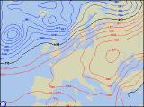
Long-range Outlook: 09/01/06 - 14/01/06
Mild & Wet NW. Colder & Drier SE.
Click here for details of the weather over the next few days.
Please note that forecasting beyond five days is notoriously difficult, and small errors at short-range can lead to large deviations further in time. Our longer-range forecasts are based on the most accurate weather data available at the time, but alterations may be required as the period progresses. Please check back regularly for the most up-to-date forecast run.
Monday 09/01/06 to Tuesday 10/01/06
High pressure over Scandinavia will have lost its grip during Monday, but it will still influence the weather across southeast England and East Anglia. Here, it will be dry and reasonably bright, and it will still be on the cold side. Across the rest of England and Wales, it will be dry with a fair amount of cloud. As winds turn more south-westerly, it will feel less cold here. A deep low pressure in the Atlantic will give strong south-westerly winds across much of Ireland, Northern Ireland and Scotland. Western coastal areas will have a risk of gales, but as a result of the southwest winds, it will be much milder. Rain will affect western parts of Ireland, together with western Scotland and much of Northern Ireland, heavy at times. Strong southwest winds will continue to blow in cloud and periods of heavy rain across Scotland and Northern Ireland during Tuesday. Further south and east across Ireland, northern England and Wales, it will be mild, but cloudy with coastal drizzle. The Midlands and southern England will have some brightness, and it will still be fairly chilly here.
 Wednesday 11/01/06 to Thursday 12/01/06
The rain is expected to slip further southeastwards during Wednesday, affecting eastern Scotland, northern England, north Wales and parts of the Republic of Ireland. To the north of this across the rest of Scotland and Northern Ireland, it will turn brighter with occasional coastal showers. Central and southern parts of England and Wales will still be dry with a fair amount of cloud around, and it will still be chillier here than elsewhere across the UK. As depressions continue to gather in the Atlantic during Thursday, the first band of rain, now across all but southeast, will gradully peter out leaving a good deal of cloud. Still chilly in the southeast, with occasional brightness. After a dry start, Ireland and Northern Ireland will see southerly winds freshening, drawing in very mild air, but also outbreaks of rain. Some of this rain will be heavy during the afternoon. The rain will also nudge into western Scotland through the day, whilst eastern Scotland has some brighter spells, in the shelter of the mountains.
 Friday 13/01/06 to Saturday 14/01/06
On Friday, weather fronts are expected to straddle most of the UK and Ireland. These will give outbreaks of heavy and persistent rain for many areas, especially southwest England, Wales, northwest England and Scotland. Ireland and Northern Ireland will start off cloudy and wet, but brighter weather with showers will move in during the afternoon. Perhaps the driest weather will once again be across southeast England and East Anglia, although brightness will be at a premium. Very little change is expected on Saturday, with rain or showers in most places. The southeast of England should just about remain dry, perhaps with an influx of slightly colder air from the near continent later. Western parts of Scotland and Northern Ireland will have some sunshine, but only between some fairly blustery showers. Mild across all but the southeast. Please check back for further forecast updates.