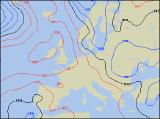
Long-range Outlook: 08/06/05 - 13/06/05
High pressure in control. Dry and bright.
Click here for details of the weather over the next few days.
Please note that forecasting beyond five days is notoriously difficult, and small errors at short-range can lead to large deviations further in time. Our longer-range forecasts are based on the most accurate weather data available at the time, but alterations may be required as the period progresses. Please check back regularly for the most up-to-date forecast run.
Wednesday 08/06/05 to Thursday 09/06/05
Wednesday's synoptic setup sets the scene for most of the week, with high pressure very much in control. The exact position of the anticyclone, relative to the UK and Ireland, will dictate exactly how much sunshine there is, and how warm it feels. Originally, we were predicting temperatures nearing the mid 20's Celsius on Wednesday, but it does now look like temperature will range from around 17C in the north, to 21C in the south. Most places will have some sunny spells, the best of these across England and Wales. Western parts of Ireland and Scotland will have more cloud, perhaps with a few spots of light rain. We're expecting the high pressure to sit just to the west of Ireland on Thursday, and this will result in a light northerly flow across the UK. Once again, the best of the sunshine will be across central and southern areas, but temperatures won't be much higher than 21C anywhere because of the northerly breeze. Once again, parts of Northern Ireland and Scotland will be rather cloudy, with a continued risk of patchy drizzle, and this cloud will sink south into northern England later.
 Friday 10/06/05 to Saturday 11/06/05
There will be very little change on Friday, as high pressure continues to dominate. A westerly flow across Northern Ireland and Scotland will allow weak weather fronts to skirt eastwards from the Atlantic, bringing a lot of cloud and a risk of patchy rain in places. A much brighter day across Ireland, and also across eastern Scotland in the shelter from the westerly breeze. Once again, England and Wales will have a mixture of sunny spells and patchy cloud. Temperatures not particularly high, but above average, so it will feel pleasant in the light winds. Although conditions will be generally settled on Saturday, conditions are also likely to be cloudier across England, Wales and Ireland. Across high ground in the west, there could even be the odd light shower. However, the best of the brightness will be in south-eastern parts of England. For Scotland and Northern Ireland, fortunes will be reversed after rather cloudy conditions during the week. Sunny spells will be more widespread, and in the light winds will feel quite pleasant.
 Sunday 12/06/05 to Monday 13/06/05
Sunday should be dry everywhere, with high pressure out to the west continuing the slight northerly drift across the UK and Ireland. Most places will have some sunny spells, although cloud will tend to build up inland during the afternoon. Because of the northerly breeze, it won't be as warm as one would expect, with highs in northern areas peaking at 16-17C, and around 20-21C in southern areas. At present, the new week looks like starting in exactly the same way as the week preceding it, with high pressure continuing to draw in settled, but rather cool conditions. One subtle difference will be across south-east England, where a north-easterly breeze will drag in a lot of low cloud from the North Sea, perhaps with coastal drizzle. Temperatures will be around average, or slightly above, and it will feel pleasant in the sunshine across western areas. Please check back for further forecast updates.