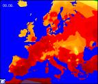
Long-range Outlook: 08/08/04 - 13/08/04
Hot and humid in many parts. Becoming increasingly unsettled.
Click here for details of the weather over the next few days.
Please note that forecasting beyond five days is notoriously difficult, and small errors at short-range can lead to large deviations further in time. Our longer-range forecasts are based on the most accurate weather data available at the time, but alterations may be required as the period progresses. Please check back regularly for the most up-to-date forecast run.
Sunday 08/08/04 to Monday 09/08/04
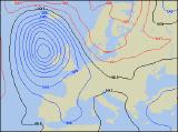
A deep area of low pressure to the west of the UK will give a strong southerly flow right across the UK on Sunday. This will drag very warm, humid air across central and eastern areas, and across parts of England it will become hot. Out to the west, weather fronts will bring cloud and outbreaks of heavy rain across Ireland and Northern Ireland, perhaps reaching south-west England by evening. On Monday, the rain out to the west will spread erratically eastwards to all parts, turning more showery as it does so. Some of the rain will become very heavy with the risk of thunder, especially in the south. Behind the rain across Ireland, Wales and western Scotland, it will become much brighter and fresher, with a mixture of sunny spells and scattered showers. Fresh south-westerly winds will continue, but will be more southerly in the east.
 Tuesday 10/08/04 Wednesday 11/08/04
The weather will be very unsettled across England and Scotland on Tuesday, with very humid and wet conditions. Showery bursts of rain will be torrential in places, with embedded thunderstorms likely. The weather across Wales, south-west England and much of Ireland will be much more settled with some sunny spells. However, during the latter part of the afternoon, yet more rain will sneak into south-western parts of Ireland. Once again, the heavy rain is expected to hang around on Wednesday, mostly affecting eastern Scotland and north-east England, where there will be some large rainfall totals. Elsewhere, with a small ridge of high pressure, it will become mostly dry with some warm sunny spells. However, there is always the risk of one or two scattered thunderstorms across southern England.
 Thursday 09/08/04 Friday 10/08/04
The end of the week is currently very uncertain, as the line between settled and more disturbed weather is very fine indeed. At present, it looks as if a slack area of low pressure will affect southern parts of England and Wales on Thursday, giving some thundery rain. Elsewhere though, it should be mostly dry with some sunshine, and although warm, it will feel a good deal fresher. Following current models, the outlook for southern parts is extremely unsettled, with long periods of thundery rain. Elsewhere, staying dry and fine with some sunshine, as high pressure builds across the north. As ever, please check back for more detail on next week's weather.